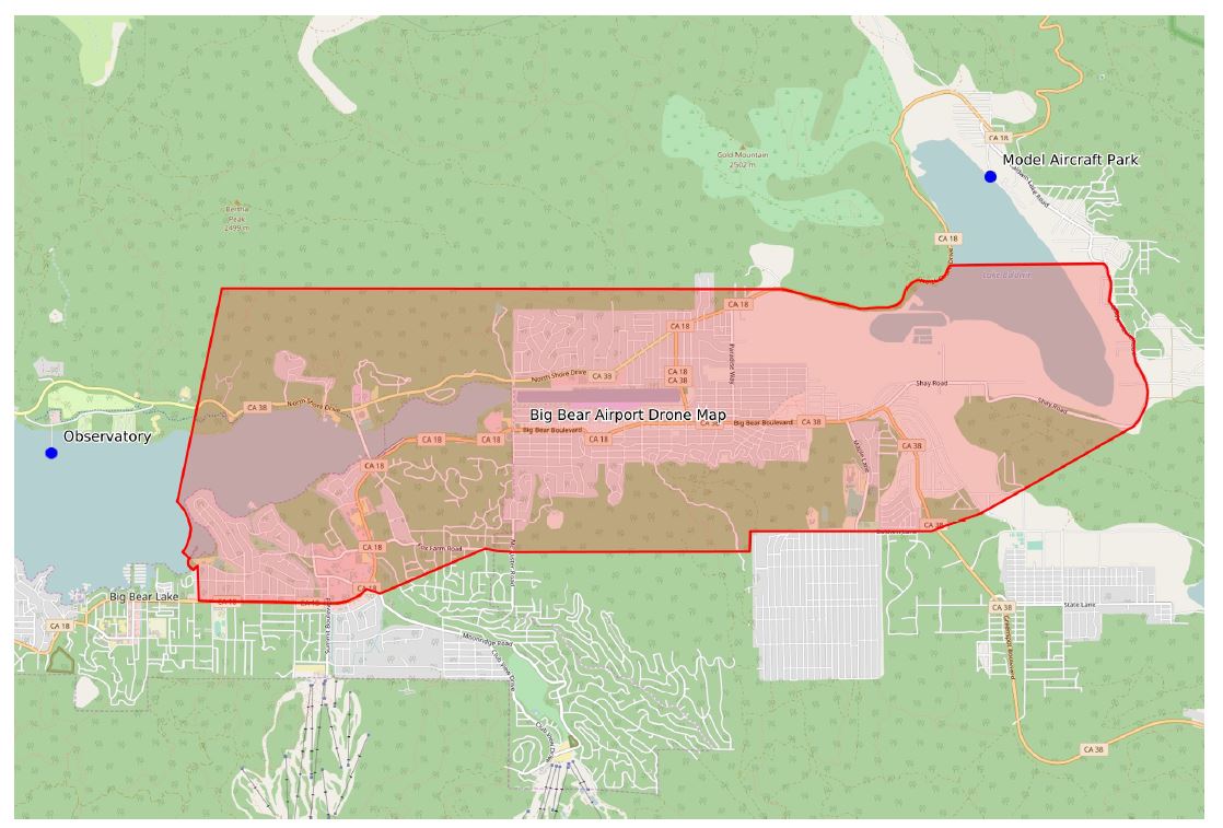
The Big Bear Airport supports the safe operation of drones for recreational use and commercial purposes. There are specific areas around the airport that are UNSAFE to fly drones because manned aircraft will be at low altitudes and, in the interest of safety, we consider them highly risky. These areas are marked in red on the map and drone use is not permitted.
However, in an effort to simplify this process, recreational drone flights outside this objectionable (red) area are permitted without the need to contact me or the airport for coordination. Please review the “know before you fly” FAA informational campaign link, do not exceed your maximum altitude requirement, and LOOK for aircraft. Contact the Big Bear Airport at (909) 585-3219 with any questions.
Safe flying and have fun.
Recreational User Guidelines-
Currently, small unmanned aircraft systems (sUAS) may be operated for hobby and recreational purposes under specific safety guidelines as established by Congress. Small UAS flown for recreational purposes are typically known as model aircraft.
Under the Special Rule for Model Aircraft, recreational UAS must be operated in accordance with several requirements, including a community-based set of safety guidelines and within the programming of a nationwide community-based organization such as the Academy of Model Aeronautics (AMA). Operators not operating within the safety program of a community-based organization should follow the FAA’s guidance.
As of Aug. 29, 2016, the Federal Aviation Administration requires all owners of small unmanned aircraft, or drones, weighing between 0.55 and 55 pounds to register online before taking to the skies.
What is recreational use of sUAS?
The recreational use of sUAS is the operation of an unmanned aircraft for personal interests and enjoyment. For example, using a sUAS to take photographs for your own personal use would be considered recreational; using the same device to take photographs or videos for compensation or sale to another individual would be considered a commercial operation. You should check with the FAA for further determination as to what constitutes commercial or other non-hobby, non-recreational sUAS operations.
What are the safety guidelines for sUAS recreational users?
- Follow community-based safety guidelines, as developed by organizations such as the Academy of Model Aeronautics (AMA).
- Fly no higher than 400 feet and remain below any surrounding obstacles when possible.
- Keep your sUAS in eyesight at all times, and use an observer to assist if needed.
- Remain well clear of and do not interfere with manned aircraft operations, and you must see and avoid other aircraft and obstacles at all times.
- Do not intentionally fly over unprotected persons or moving vehicles, and remain at least 25 feet away from individuals and vulnerable property.
- Contact the airport or control tower before flying within five miles of an airport.
- Fly no closer than two nautical miles from a heliport with a published instrument flight procedure.
- Do not fly in adverse weather conditions such as in high winds or reduced visibility.
- Do not fly under the influence of alcohol or drugs.
- Ensure the operating environment is safe and that the operator is competent and proficient in the operation of the sUAS.
- Do not fly near or over sensitive infrastructure or property such as power stations, water treatment facilities, correctional facilities, heavily traveled roadways, government facilities, etc.
- Check and follow all local laws and ordinances before flying over private property.
- Do not conduct surveillance or photograph persons in areas where there is an expectation of privacy without the individual’s permission (see AMA’s privacy policy).
Users of commercial and recreational UAS should be aware that in remote, rural and agricultural areas, manned aircraft, including fixed-wing aircraft and helicopters, may be operating very close to ground level. Pilots conducting agricultural, firefighting, law enforcement, emergency medical, wildlife survey operations and a variety of other services all legally and routinely work in low-level airspace. Operators controlling UAS in these areas should maintain situational awareness, give way to, and remain a safe distance from these low-level, manned airplanes and helicopters.